While the track positioning has now been adjusted to more closely match what I envision to be the actual arrangement, it is still just a generalized routing and will most likely change once mock-ups and sample arrangements are done on the actual benchwork. Also, this plan is really just a "stream of consciousness" rather than a well refined work at this point. In other words, so far I have just thrown on every possible feature I could think of that would make sense in a particular location. However, like the track arrangement, I suspect many of the towns, buildings and other features will end up looking quite different from how they look on the plan at this time.
Let's take a look at each of the three levels in a little more detail.
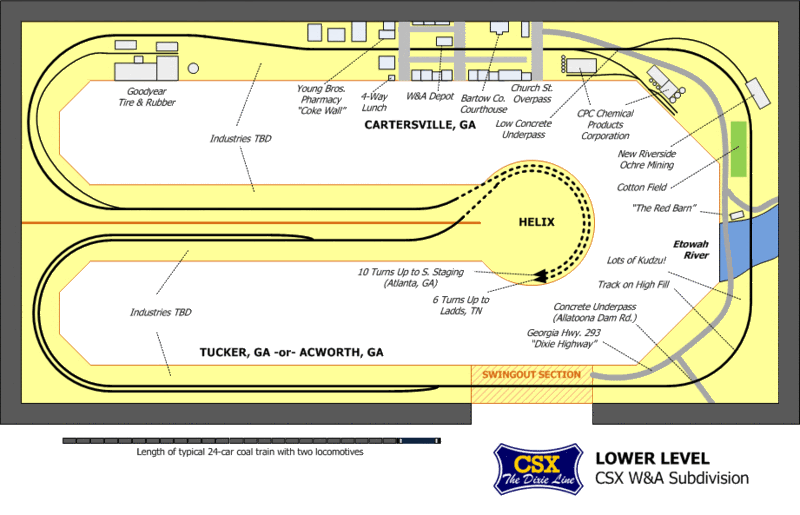
Lower Level
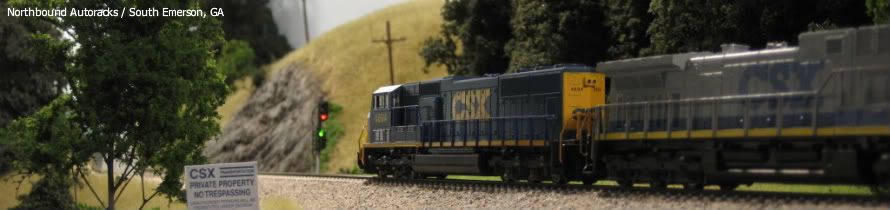
The lower level of the layout represents a section of the CSX W&A Subdivision just north of Atlanta, GA on the way to Chattanooga, TN. The section I have chosen to model extends from Acworth, GA (milepost WA34.1) north to Cartersville, GA (WA47.6). This 13 mile segment goes through the rolling hills that are so prominent in the northwestern part of Georgia. The signature scene along this line is where the CSX crosses the Etowah River on a ballasted deck bridge just south of Cartersville. The town of Cartersville will be well represented, including the depot, county courthouse, and a pharmacy that features the official first Coca Cola wall advertisement. The area on the north end of Cartersville will feature the Goodyear Tire & Rubber plant, which in real life closed in 2003 but continues to thrive on the CSX Dixie Line. There does need to be some sort of small yard and a passing siding in this area, but it is yet to be mapped out in any detail. Also, the town of Acworth will probably be replaced by the town of Tucker, GA. Although Tucker is actually on the CSX Abbeville Sub east of Atlanta, it is adjacent to my current hometown and has several features I would like to model. I may actually combine Tucker and Acworth together--this area includes a passing siding but otherwise is undeveloped on the track plan.
Middle Level
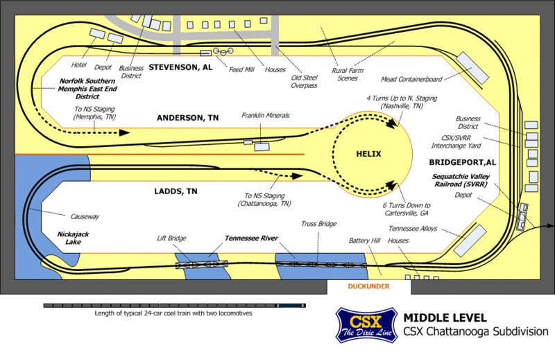
The middle level of the layout represents a section of the CSX Chattanooga Subdivision just west (timetable north) of Chattanooga on the way to Nashville. The section modeled begins at Ladds, TN (milepost J133.8) and continues northbound to Anderson, TN (J102.2). This 31 mile section of the CSX "J-Line" dips down into the state of Alabama, and the two prominent towns featured on this level are in the Yellowhammer State: Bridgeport and Stevenson. However, the signature scene on this level is the CSX double crossing of the Tennessee River at Bridgeport: one on a deck truss span and one on a lift drawbridge span. This crossing also includes a long causeway across Nickajack Lake. Norfolk Southern has trackage rights on the CSX between Chattanooga and Stevenson, and this is true on the CSX Dixie Line as well. NS trains will enter CSX tracks at Stevenson and depart near Ladds, disappearing into some yet to be determined hidden staging arrangement so that NS trains never leave the middle level of the layout. Finally, the Sequatchie Valley Railroad (SVRR) junction with the CSX at the restored Bridgeport depot will be modeled along with the interchange yard. The SVRR mainline will terminate at a wall of the layout room, with the option for expanding this line into an adjacent room to connect to a future switching style layout.
Upper Level
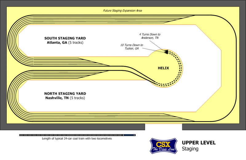
The upper level of the layout will be used exclusively for staging. Two double ended staging yards are planned: the north yard represents Nashville, TN and other points beyond the northern end of the visible layout, while the south yard represents Atlanta and other points beyond the southern end of the visible layout. Each of these yards will have five tracks, although there is some space reserved for expansion of the south (Atlanta) staging yard. Three of the tracks in each yard are more than double the length of the average train, so serial staging (more than one train stored on a single staging track) can be used as well.
.

